Last Updated: 03 May 2024.
309969 Visitors
  • alt-icon
  • SM EN
  • alt-icon
  • Find Us On

    Facebook & Twitter
  • Download

    From App Store & Google Play.

Announcement


WORK QUOTATION NOTICE  new icon.png
(Please click on Quotation Title for more information)

Quotation No.   :  JPS/IP/P/PK/S.H/4/2024(PPP)

Quotation Title  :  KERJA PENYIASATAN TANAH UNTUK REKABENTUK TERPERINCI BAGI PROJEK RANCANGAN TEBATAN BANJIR LENGGONG FASA 1 DAERAH HULU PERAK, LENGGONG, PERAK.

Briefing & Site Visit  :  Tuesday, 30/04/2024 Time 10.00 a.m. (Registration : 9.00 a.m – 9.30 a.m).

Gathering Place   : MEETING ROOM JABATAN PENGAIRAN DAN SALIRAN CAWANGAN LENGGONG, LENGGONG, PERAK

Quotation documents will be distributed starting from 02/05/2024 until 08/05/2024 after payment has been made.

Closing Date        :  THURSDAY,  09/05/2024 at 12.00 noon  (ADVERTISEMENT ERROR)


TENDER NOTICE new_icon.png
(Please click at Tender Title for more information) 
 

Tender No.   :  JPS/P/PK/SGP/9/2023

Tender Title  :  PROJEK PEMBINAAN DAN PEMBAIKAN BAN PANTAI DI KUALA KURAU, DAERAH KERIAN, PERAK

Briefing and Site Visit  :  02.05.2024 (Thursday), Time 10.00 a.m. (Registration : 10.00 a.m – 10.30 a.m)

Gathering Place  :  Setor Dan Workshop Jabatan Pengairan Dan Saliran Daerah Kerian, Jalan Perusahaan, Parit Buntar, Perak (Koordinat: 5.110069,100.488255).

Selling Date         :  03.05.2024 Till 09.05.2024 (Monday - Friday : 8.30 a.m. - 12.00 noon)

Closing Date        :  23.05.2024 (Thursday) at 12:00 noon


TENDER ASSESSMENT
(Click tender title for more information)
 

1.  JPS/N/PK/BPSP/3/2024 - PROJEK MENAIKTARAF SISTEM PENGAIRAN LUAR JELAPANG DI RANCANGAN PENGAIRAN KOTA LAMA KANAN/SAYONG SERTA KERJA-KERJA BERKAITAN, DAERAH KUALA KANGSAR, PERAK

2.  JPS/N/PK/ME/4/2024 - MEMBEKAL, MENGHANTAR, MENGUJITERIMA DAN MENTAULIAH TIGA (3) SET PAM SELAM HIDRAULIK MUDAH ALIH JENIS KANOPI AKUSTIK DAN SATU (1) SET JANAKUASA BESERTA KELENGKAPAN YANG BERKAITAN DI JABATAN PENGAIRAN DAN SALIRAN NEGERI PERAK (TAWARAN SEMULA)

3.  JPS/P/PK/SGP/8/2023 - PROJEK PENGAWALAN HAKISAN PANTAI DI SUNGAI TIANG SELATAN, MUKIM RUNGKUP, DAERAH BAGAN DATUK, PERAK


QUOTATION ASSESSMENT new_icon.png
 (Click quotation title for more information)

 JPS.PK.(BSAHE)3/2024 - PERKHIDMATAN PENYELENGGARAAN PERALATAN SERTA KAWASAN STESEN AUTOLOGGER HUJAN DAN ARAS AIR INTUK TAHUN 2024 MILIK JPS NEGERI PERAK


Information Centre

Directory   Publication   Mobile Apps   RSS   audio   video   Client's Charter   Client's Charter Achievement   Online Transaction Report
Directory   Publication   Mobile Apps   RSS    Audio    Video   
Client's
Charter
 
Client's
Charter
Achievement
 
Online
Transaction
Report

Facebook Feed

Tags Cloud

Contact Us

Perak Drainage and Irrigation Department
Jalan Panglima Bukit Gantang Wahab, 30000 Ipoh.
Tel: 605-209 5000 Fax: 605-254 0290
Email: jpspk[at]perak[dot]gov[dot]my

Location of JPS Ipoh Perak :
N 06° 06.365' / E 102° 15.606'
http://maps.google.com/

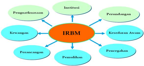
IRBM is the process of adjustment in the care, management and development of water resources, land and related resources across all sectors within a river basin. IRBM aims to maximize socio-economic benefits for sustainable water resources and at the same time preserve and restore natural ecosystem water resources. It is a sustainable management of land and water by natural geographical border regardless of the administrative boundary. IRBM objectives is to ensure that sufficient water, clean water, reducing the risk of flooding and improve the environment. Implementation of effective IRBM requires the involvement of various stakeholders to play their respective roles especially in 8 components IRBM.

Diagram Components IRBM

sample_1

The Definition Of River

Sungai means water bodies in mainland normally flow in the surface of the land or is likely to flow through an underground tunnel. The national land code 1965 interpret rivers any river, stream, caruk or other natural flow, and any branches of the River, the flow-delta or detour made thereof.

The Definition Of River Basin

River basin means the area of land from which all surface runoff flows through a network of subsidiary rivers, major rivers, and the possibility of Lake and ends into the sea through a kuala, estuary or delta.